
The inflows and outflows of the Bog’s water, its Water Budget, are crucial to understanding the wetland. Learn about the relative magnitudes of all the Water Budget components.
The Water Budget of Cedarburg Bog
Jim Reinartz
In the last two issues of the BogHaunter we explored the Cedarburg Bog’s glacial history, basin depth and shape, and history as a peri- and postglacial lake. The water budget of the Bog and its relationship with local groundwater follows naturally from those topics.
A useful analogy for the water budget of the Bog might be that the Bog is a giant lung that “breathes” water rather than air. Whenever it rains, the Bog takes on excess water, or “inhales” water and swells, as our lungs enlarge when taking a deep breath. Between rains, the Bog “exhales” and shrinks, releasing water to the atmosphere from its surface and vegetation.
Water Budget
The Water Budget is an accounting of all the inflows, outflows, and changes in water storage within the Bog over a defined period, such as one year. We don’t precisely know the details of the Bog’s water budget because most of the inflows and outflows can only be estimated. The estimated orders of magnitude of the inflows and outflows of water are shown by the relative size of the arrows in the Water Budget Figure 1.
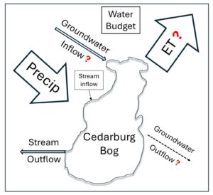
Figure 1. Water Budget model for the Cedarburg Bog (or any wetland for that matter). Precip = Precipitation; ET = Evapotranspiration. Question marks indicate budget components that can only be roughly estimated (ET), and groundwater inflows and outflows that can’t be measured or estimated well at all. The only way to estimate groundwater flows would be to balance the budget if all the other inputs and outputs were known, which they are not.
Inflow
Precipitation directly onto our 2,300-acre wetland is by far the largest source of water in the system. Groundwater flow into the wetland is important for the chemical budget of the Bog but is likely a minor source of the volume of water. Local overland flow (and very local and shallow seepage from saturated soils) is another minor source compared to direct precipitation. Stream flow from one very small and intermittent stream brings a small quantity of water into the Bog from north of Knollwood Road just east of Blue Goose.
Outflow
There are three potential avenues for water to flow out of the Cedarburg Bog. The largest by far is evapotranspiration (water lost to the atmosphere through evaporation (from the soil and water surfaces) and transpiration (from plants). Stream flow in the outlet stream on the west side of Mud Lake constitutes a much smaller portion of the water leaving the Bog. Groundwater recharge, or flow of water from the Bog into the ground, is likely a very small, perhaps insignificant, cause of water loss.
Estimated Budget Components
Precipitation is, along with streamflow, one of the water budget components that we can measure accurately. The long-term average annual precipitation on the Bog is about 35”, and the annual totals for most years fall between 30” and 40”.
How does that compare to annual loss to the atmosphere through evapotranspiration, ET for short? UW Extension AgWeather (https://agweather.cals.wisc.edu/) has modeled Potential ET using satellite-derived measurements of solar radiation and average air temperatures for any specific location for the past three years. Potential ET is the maximum amount of water that will be lost to the atmosphere through evapotranspiration where water is readily available, and the plants never face a water deficit (like the Bog).
From 2022 to 2024 the annual Potential ET at the Bog has ranged from 32” to 34”, averaging 33.4” over those three years. Precipitation from 2022 through 2024 was a little higher than normal, averaging 37.9” per year (https://www.ncei.noaa.gov/ NOAA National Centers for Environmental Information). With precipitation averaging about 35” per year, and using 33.4” as average ET loss annually, we see that the two are nearly balanced. If we have a very big saucer with a lot of storage capacity (the Bog), it will have water in it all the time and sometimes run over a little.
With the really big input (precipitation) and output (ET) of our water budget nearly in balance, let’s look at the other smaller components. One other component of our budget that we can, at least in theory, measure accurately is flow in the single outlet stream. With the United States Geological Survey, we measured flow in the outlet stream in 1983 and 84 (https://waterdata.usgs.gov/). We have a complete year of flow records from 6/22/1983 through 6/21/1984. Average flow over that year was 55,700 ft3/day, with a maximum flow of 189,216 ft3 on 2/20/1984, and a minimum of zero on several days in late July, August, and early September. I converted the total flow out of the Bog over the year (20,390,000 ft3) to 468 Acre-feet, or the depth that volume of water would be if it was spread over a one-acre area. I can then divide those 468 acre-feet by the 2,300 acres of the Bog and convert to inches to find that a depth of 2.44” of water was removed by the stream from the area of the Bog over an entire year. This 1983-84 period had a nearly normal total precipitation of 36.5”.
Summary
Let’s review our water budget so far, (35” Precip. In) – (33.4” ET Out) – (2.4” Stream Out) = (-0.8” Negative Balance). What have we learned so far? 1) With these three budget items that can be measured or estimated somewhat accurately compared to the others, we have a nearly balanced budget. 2) Total stream flow out (measured only one year) is less than 7% of the volume of water that falls as precipitation on the Bog in a year. 3) If we would assume that the flow in from the one tiny intermittent stream and leakage out to the groundwater are both negligible, it would require only 0.8” of groundwater inflow (or a volume 2.3% of the precipitation total) to balance our budget. 4) The idea, once widely promulgated, that the Bog itself is a major source of recharge to the groundwater of the region does not make sense.
In the next newsletter, I will discuss what we know (and what I think) about the groundwater flow into the Bog, and why I think that the Bog’s leakage into the ground is negligible. There is no way to measure groundwater inflow to or outflow from the wetland. We do, however, know that groundwater does flow into the Bog because we can visit at least five discreet springs. The only way to estimate the volume of groundwater flows would be to balance the budget if all the other inputs and outputs were known. The major budget component ET cannot be modeled or estimated with enough precision to have any confidence in estimates of groundwater flows by solving the budget equation.
To summarize this analysis of the Bog’s water budget, let’s put some roughly estimated numbers on our model of the water budget in Figure 2. Over a short period, the change in storage (the amount of water contained in our big saucer) can be dramatic. During times of excess rainfall water levels in the Bog rise substantially; during droughts water levels fall and the outlet stream runs dry. However, over the long-term, the Bog’s water budget must balance. Precipitation and Evapotranspiration reign supreme in our wonderful wetland.
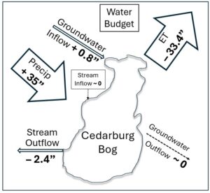
Figure 2. Water Budget of the Bog with roughly estimated input and output values that would balance the budget. The numbers are in inches reflecting that depth of water spread over the 2.300-acre wetland.
