
Jim Reinartz, FOCB President
In the last newsletter I wrote about how multiple glacial advances right to the edge of the Bog can explain the extreme glacial topography of the UWM Field Station’s Beech-Maple Forest and the formation of the Cedarburg Bog basin. Now I want to describe what we know about the depth contours of the peri- and post-glacial lake that forms the basin of the Bog.
Over decades at the UWM Field Station we researched the depth and shape of the basin filled with lake sediments and organic peat and muck that is the wetland soil. Research seems too fancy a word for the process of knowing where you are and pushing a probe with a small corer at the tip to discover how deep it is to the bottom, and bringing up a small piece of the mineral base to characterize its consistency. The laborious work was done mostly in the winter (cut a hole in the ice and record the depth). As part of various projects, the Bog basin has been sounded at 611 locations over 45 years. But this work is far from complete; some areas have been sampled intensively while some large areas have not yet been systematically probed (see sample dots on Bathymetric Map).

Contour map of the Cedarburg Bog basin. Sample points are shown as dots. Contours are meters below the wetland, or standing water, surface. Seven glacial islands in the Bog are apparent.
Although incomplete, we do have a general picture of the Bog’s basin depth (Bathymetric Map). The topography of the glacial sand and gravel underlying the Bog is much like that of the adjacent upland of the Field Station. Except that it is low enough to be below the water table and the surface of the lake that filled the basin in the past. Parts of the basin are gently rolling; other parts have deep kettle holes and high mounds that may be small kames and eskers formed at the margins of the ice sheet.
The northern end of the Bog has deep (> 40ft, 13m) holes under Big and Little Horn and Watt’s Lakes. Much of the central and southeastern portion of the wetland appears to have gently undulating topography from 15’ to 30’ below the wetland surface, although there is a known deep spot 40’ (>12m) deep just west of Long Lake. There is also plenty of room for deep holes in unstudied parts of the Bog between our depth-sounded transects. The known deep kettle-hole topography in the Bog is between the three islands (two with the boardwalk trail), where holes over 50’ (15m) below the surface are in near proximity to islands almost 20’ above the wetland. This area is a lower-elevation extension of the deep kettle topography above the water table in the Field Station’s forest to the west.
The Lake
The Bog basin was a lake for thousands of years during the later periods of glaciation and after the glaciers receded. The west island on the UWM boardwalk trail appears to show evidence of three different lake levels during the glacial period: 1) The very flat top of the island (see LIDAR figure) suggests that there was a lake just a couple feet deeper than the top of the island and that wave and ice action over time scoured the island flat; 2) An ice-berm ridge rings the entire island. Ice berms are formed at the margins of large shallow lakes when expansion and contraction of ice exerts tremendous forces on the shore and pushes rocks and gravel into a mound. This ice berm, surrounding the island and most of the Bog, is at too high an elevation to be formed by a lake at the current wetland surface; and 3) At the outer margin of a flat terrace around the base of the island, is a smaller ice-berm that would have been formed by a lake at the current elevation of the wetland.
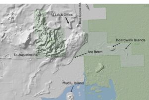
LIDAR (Light Detection and Ranging which uses a pulsed laser to measure detailed topography) shaded contour map of the Field Station and Bog islands.
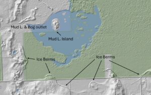
LIDAR shaded contour map of the south end of the Bog showing distinct ice-berms.
During the glacial period, very fine sediments settled to the bottom of the lake and formed the impervious clay lining that holds water in the Bog today. Following the glacial period, the large shallow lake must have been very productive with summer-warmed calcareous water that over centuries filled with sediments and organic matter from all of the plants and animals that lived, pooped, and died in the lake basin. That organic lake sediment is the almost gelatinous gray material 8’ below the surface in the deep parts of the Bog today. When the lake filled to be shallow enough for even more productive emergent aquatic plants to grow, they died, did not fully decompose, and accumulated to be the pure-organic peat and muck now found at the surface of the wetland.
The picture of a flat lake at the depth of the surface of the wetland today is too simplistic because today’s wetland is not flat. Watt’s Lake at the north end (~871’ ASL) is six feet above Mud Lake (~865’ ASL). The only surface water outlet from the Bog is from the western side of Mud Lake at the south end; water flows slowly and steadily from the higher north end of the Bog to the south and Mud Lake. That means that if the basin was filled with a flat lake today it would be very shallow at the north end and probably would not even form one continuous lake all the way north to the south. The north end “grew” higher because as the sodden and spongy peat and muck built up over time it impeded the flow of water and kept the surface continuously wet, supporting a productive wetland plant community.
There is much still to be studied and learned about the Bog basin, its geology and formation, but the picture drawn here hints at the influence the basin had on the complex hydrology and development of plant communities that give us the magnificently diverse wetland we have today.
